In this short pause between the perturbations, today the mountains have shown themselves to be well snowed above 2,700 / 2,800 meters.
In detail, the forecasts announce that until tomorrow, Thursday 24, large-scale circulation will be characterized by the presence of a large area of low pressure slowly moving towards southern Italy. His influence on the weather in our region will end on Friday. Therefore today temporary dry break with beautiful sunny spells, but already from the evening we will have the first rains; Thursday disturbed with clouds and rainfall and from Friday time in a definite improvement with stable weather until at least Tuesday.
The activity in the mountains will probably resume close to the weekend, with conditions still to be evaluated, even if the snowfalls of recent days will have a rather long train. On average, it will be pleasant to take advantage of the autumn conditions to walk the paths of our beautiful valleys. In any case, it is recommended to pay close attention to the watercourses which, with the abundant precipitations, can assume impetuous character even when in summer the flow is usually scarce.
Fondazione Montagna Sicura - Courmayeur
Mountain conditions: the autumn conditions that have been established in recent days will continue for a few days. From the Regional Functional Center the forecasts announce in fact the minimum depression directed towards the Portuguese coasts will continue to send disturbed flows, with precipitation that will continue this afternoon. Tomorrow the minimum will shift, allowing a wedge of high pressure to expand also towards the Valle d'Aosta, bringing more stable conditions and temperatures slightly higher due to the call of more mild African air. But Wednesday the minimum will regain strength, again conditioning the weather with rainfall on Thursday and falling snow levels. Improvement later.
The amount of snow deposited on the ground, being very windy, is not easily quantifiable (up to 40 cm) due to the inhomogeneity of its distribution. This contribution is gradually transforming the conditions, making the situation of mixed routes slowly evolve - after the extremely dry summer - towards more normal conditions. However, the weather situation is not allowing the mountaineering activity (if not in a very limited way on the easiest and closest routes to the cable cars); of course for the rock roads, at medium and high altitudes, the structures are snow-covered and wet.
As for the trails and hiking, snow is currently confined to altitudes above 2,500 / 2,700 meters; be careful, however, to assess the exposure well: in this period of great temperature changes, it is often possible to find areas in the shade that are fresh and still covered with snow, although in the sun you still walk in a t-shirt! However, walks immersed in autumn colors are an experience not to be missed.
Fondazione Montagna Sicura - Courmayeur
The second week of October opens with a first weak autumn snowfall that has reached the mid-mountain (lower limit at around 2,000 meters in the Upper Valley) whitening the landscape. Let's see in detail the weather evolution.
The high pressure on the Middle Atlantic tends to strengthen until Friday with a rise in temperature to a decidedly warmer climate tomorrow, but with a probable incursion disrupted on Wednesday. After the snowfall of this night, today the day will be sunny with some initial residual cloudiness, located in particular on the ridges. The strong winds at altitude are attenuated until they become weak in the afternoon; also the foehn in the valleys is expected to be attenuated. Thermal zero from 2100 meters up to 3300 meters.
General conditions in the mountains: in the high mountains the activity is significantly reduced, the snow and the wind have diverted the climbers towards the medium and low altitude rock routes. To assess the evolution at altitude it is necessary to wait for the new impulse of the next few days and see its effects. In medium mountain, considering hiking activity, the snow fallen above 2,000 meters, should quickly melt, but beware of the shady slopes (north) where it will be possible, especially early in the morning, to find ice on the ground. It could therefore better to prefer sunny routes and paths, at least for the days of today and tomorrow.
Fondazione Montagna Sicura - Courmayeur
Close to the weekend, we update you on the general conditions in the mountains.
From the meteorological point of view, the conditions are typically autumnal, with more pretty cold temperatures. In detail, the western currents will bring on the Aosta Valley an alternation of weak disturbances; between Sunday evening and Monday, cold air from the north will cause a temporary drop in temperatures with possible weak snowfall even in medium mountain areas, while later there will be a partial anticyclone comeback with a subsequent return to an Atlantic flow.
As for the alpinism, the situation does not seem to favour a great activity in the high mountains. The faint snowfalls that have just fallen (between 10 and 20 cm) have created accumulations on the ledges and clogged the cracks, precluding rock activity for a few days. For the other routes, the more classic ones remain (Aig. Entreves, Dente del Gigante, Marbrées ...) but great attention is recommended to the presence of snow. For the rest, pay attention to the covering effect of the holes that snow has often made on glaciers: caution.
In the mountains, hiking and rock climbing are practiced without any particular problems, but beware of snow or glass walls above 2400 m, particularly on the northern slopes. It should also be noted that some paths in the shade or in the woods can be damp and have slippery tracts at this time of year.
Fondazione Montagna Sicura - Courmayeur
The second weekend of September is about to begin; let's see what conditions the mountain will have in the coming days.
News from the meteorological point of view: a vast trough favors the current marked cloudiness on our region with some precipitation, especially in the low valley. From tomorrow clearings are expected in progressive extension, accompanied also by some episodes of foehn. The temperatures, already in the descent phase, will tend to fall even further, with the isotherm reaching up to 2,300 - 2,400 meters on Sunday (in some sectors minimum night-time temperatures below zero, already around 2,000 meters). Attention therefore to the windchill effect which, with the northern winds, will tend to be felt in a decisive manner.
High mountains: this morning the high altitude refuges awoke under a layer of snow of varying thickness depending on the area. The rain / snow limit has sometimes dropped to around 2,600 meters (especially in the eastern quadrants) and snow events could still be repeated today. It follows that the conditions for the weekend will be rather unfavorable to the attendance of the higher altitudes, also considering the wind forecast for Sunday. The rock routes will be affected by today's snow spray, while mixed routes (despite the cold and snow that help to evolve the situation) will continue to present the same problems of the past few days. It is therefore advisable to carefully evaluate the available options with great caution or to orientate your choices towards lower altitudes.
Please note that the Boccalatte Piloti Refuge has closed its season and that the access path to it has been closed by order of the Municipality of Courmayeur (see post).
Mountain and hiking: the Tor des Géants weekend is upon us. Today at noon the longest race of the event has started, the "Tor des Glaciers" which precedes the start of the late summer queen race, scheduled for Sunday at 12.00. At a general level, the lower temperatures of these days and the snowfalls of today should not be too disturbing for the participants in the competition, who may however encounter some difficulties at the highest hills. In terms of hiking, the "randonneurs" are advised to equip themselves with appropriate clothing, given the cooler temperatures, and not to underestimate the windichill effect. The snow has not yet practically affected the trails around Mont Blanc, but the cold front, arriving from the north on Sunday, could create some discomfort, particularly on the hills on the border with Switzerland.
Fondazione Montagna Sicura - Courmayeur
The first week of September begins with good weather, but with fewer degrees. Here is the update of the conditions in the mountains.
Weather: this night's rapid disturbance is giving way to an expanding high-pressure field from the west that has already caused a rotation of currents from the north. It follows sunny weather and fresher air especially today; an increase in temperatures is expected tomorrow and Wednesday, with more clouds on Thursday.
High mountains: even for this beginning of September there are no great variations on the conditions of the different sectors of Mont Blanc. On the glaciers, in some areas, the action of leaching caused by rains and thunderstorms is clearly visible, which, together with the heat at the end of August, have contributed to the reduction of the snow cover and the thinning of snow bridges. As already mentioned, the approaches are therefore sometimes tortuous but visible.
Focus at Rifugio Dalmazzi: from today and until September 15, the refuge will observe the following schedule:
- Saturday and Sunday open all day;
- from Monday to Friday open from 3.00pm until 8.30am; closed between 8.30 am and 3.00 pm, ie lunch time; open for evening service on half board.
Mountain and hiking: once the UTMB week is over and waiting for the Tor des Géants, the trails around Mont Blanc will return to be relatively less frequented. The shelters are still open and the conditions of the paths are signalled to be still good (some traces of storms without criticality). Recall that the Courmayeur Mont Blanc Funivie ropeways closed yesterday and will reopen on November 30th.
Fondazione Montagna Sicura - Courmayeur
The last week of a particularly hot August has begun. Let's see how the conditions of the coming days are presented.
The Regional Functional Center announces a temporary anticyclone comeback that favors some more stable and sunny days until tomorrow. The next evolution is uncertain, but the approach of a low depression area from Wednesday seems likely.
The Regional Functional Center informs us that, from a meteorological point of view, an unstable circulation will remain in the next few days, with alternating lightening and clouding with occasional showers, especially in the afternoon.
In the high mountains, the mountaineering activity has restarted practically only from today, after the spell of bad weather in recent days. We therefore await the return information from industry professionals to detail the situation. Meanwhile, we draw attention to the presence of snow accumulations and the risk of snowfall at high altitudes. Specifically, particular caution is advocated by the French colleagues of La Chamoniarde on some routes (such as the route des Trois Monts on the Mont Blanc). Yesterday's snowfalls, which mainly impacted the Chamonix side, accompanied by strong winds, may have hidden some crevasses and created precarious bridges. On some slopes, recent snow often serves as a cover, barely concealing live ice or glacier fractures. As for the rock roads, some walls were still white this morning, but the sun should quickly clean up the surfaces. Be careful, however, on the northern slopes where ice and snow could clog cracks and corners in the shade for a few days.
The excursion activity is resumed at full speed (on the Tour du Mont Blanc it has practically not been interrupted). The trails around Mont Blanc are often frequented by trailers who are preparing for the UTMB, in anticipation for next week. Preparations for the organization of the race are already underway; in this regard, it should be remembered that on 31 August, the Dolonne cable car and the Chair lift Maison Vieille Courmayeur Mont Blanc Funivie, will open extraordinarily at 6 am.
Fondazione Montagna Sicura - Courmayeur
The beginning of this week welcomed us with the arrival of clouds and some precipitation; let's see what will happen for the next few days.
From a meteorological point of view, after a long period of pleasant summer weather, from yesterday evening a vast perturbed front reached the Valle d'Aosta. For today great variability is expected with alternating dry and showers or thunderstorms, while tomorrow precipitation will be more intense and frequent. This situation will be associated with a drop in temperatures that will record an isotherm of 0 degrees around 3,600 / 3,800 meters today, 3,400 / 3,600 meters tomorrow. The next evolution is uncertain, with a possible partial anticyclonic recovery only from mid-week.
High mountains: the situation that has continued to this day, characterized by high altitude and very dry areas, could undergo evolution (already this morning a very light layer of snow settled above 3,500 meters). From mid-week we will be able to verify any improvements and changes for the various sectors.
Medium mountain: the rains arriving especially the next night and tomorrow, even if not foreseen as particularly intense, could sometimes cause phenomena of increase in the flow of streams and watercourses that could present problems in their crossing. Recall that, especially in the mountains, it may happen that the center of greatest intensity of rainfall causes waves of floods that quickly reach slopes even far from the heart of the storm. It is therefore recommended to pay particular attention along the paths, especially where watercourses and streams are crossed (the latter, even if normally dry, with thunderstorms could give rise to even major runoff phenomena).
Fondazione Montagna Sicura - Courmayeur
Update for the weekend on the mountain situation.
From the METEO point of view, the atmospheric instability that brought clouds, some showers and temperatures slightly decreased between last night and this morning will be followed by the return of good weather which should last until Monday. From Tuesday a vast and deep North-Atlantic trough will determine a week of humidity and instability with showers.
Helbronner Sector / Turin Refuge: good frequentation of the routes on the satellites with refreezing that allows the approach without major problems (surmountable terminals). For the other routes, numerous roped parties on the crossing of the Aiguille d'Entrêves and the Marbrées. Access to the Gingiva / Dente del Gigante - Rochefort continues to deteriorate and is now definitely dry: for this stretch maximum attention is required. Rare cordate on the Diables where, even here, the access is very delicate and dry. Situation even more complicated at Kuffner. Still a few roped parties on the crossing of the Jorasses with descent from the normal, but the live advice remains to carefully evaluate the situation of the sections on rock that have often uncertain conditions.
Brouillard / Freney / Monzino sector: in this area the situation is constantly changing. Various rope groups concentrate on the rock roads of the Aiguille Croux and the Noire de Peuterey, but the situation is more delicate at the higher altitudes, frequented by very rare roped parties. Access to the Eccles still presents a fair practicability of the glacier, but the great high-altitude routes are characterized by conditions that require extreme caution and a willingness to desist.
Focus on the French side (information reported to us by La Chamoniarde): the Des Cosmiques refuge has some difficulties with the telephone, in case of need do not hesitate to insist. The route of the Trois Monts al Bianco still has a potentially unstable serac in the upper part of the Tacul (along the axis of the track). Serac falls, it is known, represent an objective risk in this way, for which everyone must make their own decision independently. It is possible to form an opinion on the situation on the north side of the Mont Blanc du Tacul by looking at the Aiguille du Midi webcam. However, the terminal at the bottom of the slope is opening and there are no equipped sections; it is therefore necessary to use 2 ice axes at least for the first group.
Via Normale Francese da Goûter: "normal" situation in the couloir of the Goûter which appears dry, with few rocks moving only early in the morning. From the latest news, the ice does not seem to be far from emerging on the arête des Bosses.
The refuge des Grands Mulets closed yesterday, Thursday 1 August.


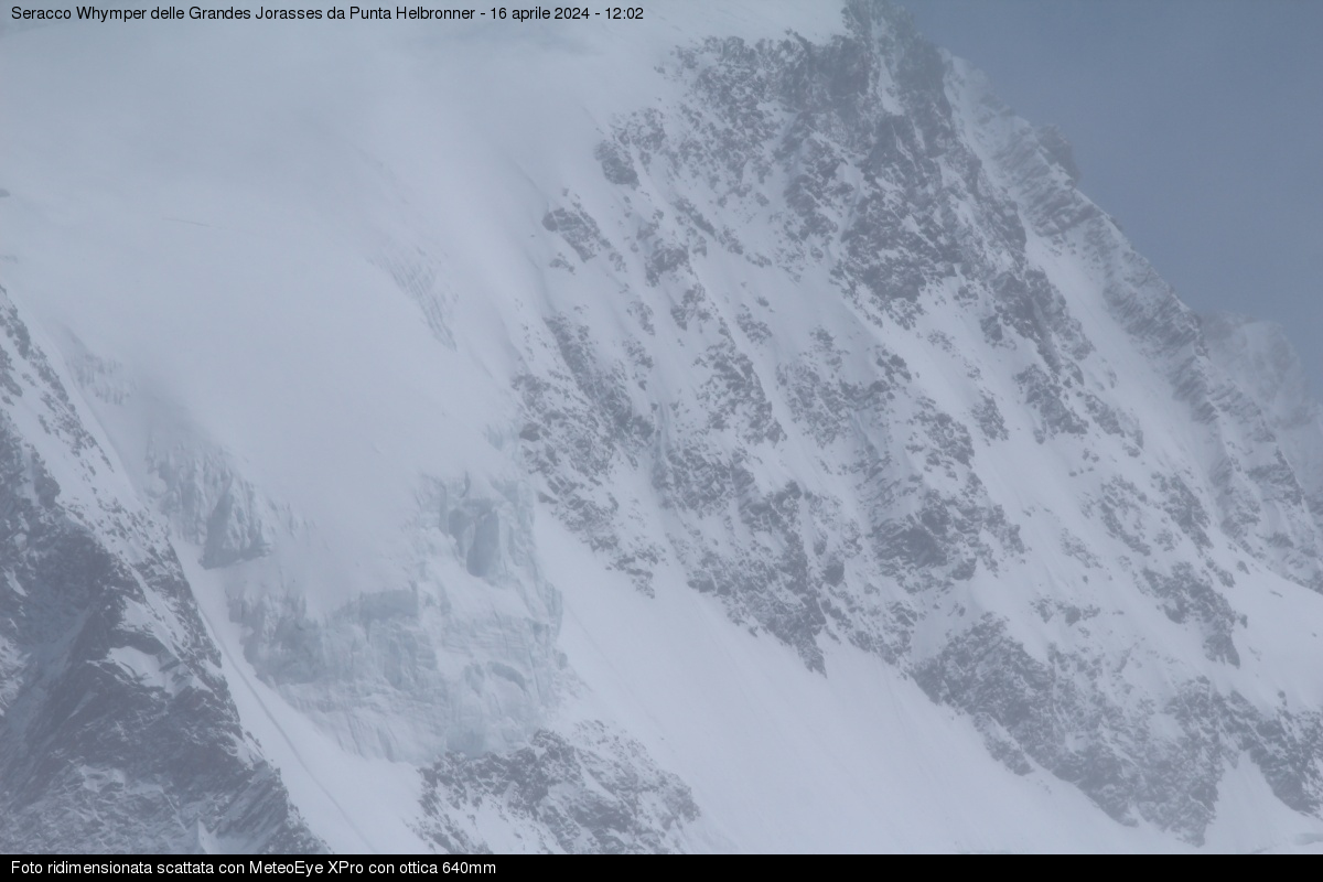
In this short pause between the perturbations, today the mountains have shown themselves to be well snowed above 2,700 / 2,800 meters.
In detail, the forecasts announce that until tomorrow, Thursday 24, large-scale circulation will be characterized by the presence of a large area of low pressure slowly moving towards southern Italy. His influence on the weather in our region will end on Friday. Therefore today temporary dry break with beautiful sunny spells, but already from the evening we will have the first rains; Thursday disturbed with clouds and rainfall and from Friday time in a definite improvement with stable weather until at least Tuesday.
The activity in the mountains will probably resume close to the weekend, with conditions still to be evaluated, even if the snowfalls of recent days will have a rather long train. On average, it will be pleasant to take advantage of the autumn conditions to walk the paths of our beautiful valleys. In any case, it is recommended to pay close attention to the watercourses which, with the abundant precipitations, can assume impetuous character even when in summer the flow is usually scarce.
Mountain conditions: the autumn conditions that have been established in recent days will continue for a few days. From the Regional Functional Center the forecasts announce in fact the minimum depression directed towards the Portuguese coasts will continue to send disturbed flows, with precipitation that will continue this afternoon. Tomorrow the minimum will shift, allowing a wedge of high pressure to expand also towards the Valle d'Aosta, bringing more stable conditions and temperatures slightly higher due to the call of more mild African air. But Wednesday the minimum will regain strength, again conditioning the weather with rainfall on Thursday and falling snow levels. Improvement later.
The amount of snow deposited on the ground, being very windy, is not easily quantifiable (up to 40 cm) due to the inhomogeneity of its distribution. This contribution is gradually transforming the conditions, making the situation of mixed routes slowly evolve - after the extremely dry summer - towards more normal conditions. However, the weather situation is not allowing the mountaineering activity (if not in a very limited way on the easiest and closest routes to the cable cars); of course for the rock roads, at medium and high altitudes, the structures are snow-covered and wet.
As for the trails and hiking, snow is currently confined to altitudes above 2,500 / 2,700 meters; be careful, however, to assess the exposure well: in this period of great temperature changes, it is often possible to find areas in the shade that are fresh and still covered with snow, although in the sun you still walk in a t-shirt! However, walks immersed in autumn colors are an experience not to be missed.
The second week of October opens with a first weak autumn snowfall that has reached the mid-mountain (lower limit at around 2,000 meters in the Upper Valley) whitening the landscape. Let's see in detail the weather evolution.
The high pressure on the Middle Atlantic tends to strengthen until Friday with a rise in temperature to a decidedly warmer climate tomorrow, but with a probable incursion disrupted on Wednesday. After the snowfall of this night, today the day will be sunny with some initial residual cloudiness, located in particular on the ridges. The strong winds at altitude are attenuated until they become weak in the afternoon; also the foehn in the valleys is expected to be attenuated. Thermal zero from 2100 meters up to 3300 meters.
General conditions in the mountains: in the high mountains the activity is significantly reduced, the snow and the wind have diverted the climbers towards the medium and low altitude rock routes. To assess the evolution at altitude it is necessary to wait for the new impulse of the next few days and see its effects. In medium mountain, considering hiking activity, the snow fallen above 2,000 meters, should quickly melt, but beware of the shady slopes (north) where it will be possible, especially early in the morning, to find ice on the ground. It could therefore better to prefer sunny routes and paths, at least for the days of today and tomorrow.
Close to the weekend, we update you on the general conditions in the mountains.
From the meteorological point of view, the conditions are typically autumnal, with more pretty cold temperatures. In detail, the western currents will bring on the Aosta Valley an alternation of weak disturbances; between Sunday evening and Monday, cold air from the north will cause a temporary drop in temperatures with possible weak snowfall even in medium mountain areas, while later there will be a partial anticyclone comeback with a subsequent return to an Atlantic flow.
As for the alpinism, the situation does not seem to favour a great activity in the high mountains. The faint snowfalls that have just fallen (between 10 and 20 cm) have created accumulations on the ledges and clogged the cracks, precluding rock activity for a few days. For the other routes, the more classic ones remain (Aig. Entreves, Dente del Gigante, Marbrées ...) but great attention is recommended to the presence of snow. For the rest, pay attention to the covering effect of the holes that snow has often made on glaciers: caution.
In the mountains, hiking and rock climbing are practiced without any particular problems, but beware of snow or glass walls above 2400 m, particularly on the northern slopes. It should also be noted that some paths in the shade or in the woods can be damp and have slippery tracts at this time of year.
The first week of September begins with good weather, but with fewer degrees. Here is the update of the conditions in the mountains.
Weather: this night's rapid disturbance is giving way to an expanding high-pressure field from the west that has already caused a rotation of currents from the north. It follows sunny weather and fresher air especially today; an increase in temperatures is expected tomorrow and Wednesday, with more clouds on Thursday.
High mountains: even for this beginning of September there are no great variations on the conditions of the different sectors of Mont Blanc. On the glaciers, in some areas, the action of leaching caused by rains and thunderstorms is clearly visible, which, together with the heat at the end of August, have contributed to the reduction of the snow cover and the thinning of snow bridges. As already mentioned, the approaches are therefore sometimes tortuous but visible.
Focus at Rifugio Dalmazzi: from today and until September 15, the refuge will observe the following schedule:
- Saturday and Sunday open all day;
- from Monday to Friday open from 3.00pm until 8.30am; closed between 8.30 am and 3.00 pm, ie lunch time; open for evening service on half board.
Mountain and hiking: once the UTMB week is over and waiting for the Tor des Géants, the trails around Mont Blanc will return to be relatively less frequented. The shelters are still open and the conditions of the paths are signalled to be still good (some traces of storms without criticality). Recall that the Courmayeur Mont Blanc Funivie ropeways closed yesterday and will reopen on November 30th.
The last week of a particularly hot August has begun. Let's see how the conditions of the coming days are presented.
The Regional Functional Center announces a temporary anticyclone comeback that favors some more stable and sunny days until tomorrow. The next evolution is uncertain, but the approach of a low depression area from Wednesday seems likely.
In the high mountains there are no particular changes compared to the past few days, so we renew the recommendations made in our previous updates.
In the middle of the mountains and on the trails, a particularly intense week is expected: in fact, starting today, the various races of the Ultra Trail du Mont Blanc © are held. We remind you that these last ones absolutely do not prevent normal hikers from being able to walk on the paths around the Mont Blanc, indeed they can be the occasion to support the trailers in the race. To find out which races run along the paths of the Italian white valleys and to check the possible times of the passages, consult the official website of the event: https://utmbmontblanc.com/it/home
The Regional Functional Center informs us that, from a meteorological point of view, an unstable circulation will remain in the next few days, with alternating lightening and clouding with occasional showers, especially in the afternoon.
In the high mountains, the mountaineering activity has restarted practically only from today, after the spell of bad weather in recent days. We therefore await the return information from industry professionals to detail the situation. Meanwhile, we draw attention to the presence of snow accumulations and the risk of snowfall at high altitudes. Specifically, particular caution is advocated by the French colleagues of La Chamoniarde on some routes (such as the route des Trois Monts on the Mont Blanc). Yesterday's snowfalls, which mainly impacted the Chamonix side, accompanied by strong winds, may have hidden some crevasses and created precarious bridges. On some slopes, recent snow often serves as a cover, barely concealing live ice or glacier fractures. As for the rock roads, some walls were still white this morning, but the sun should quickly clean up the surfaces. Be careful, however, on the northern slopes where ice and snow could clog cracks and corners in the shade for a few days.
The excursion activity is resumed at full speed (on the Tour du Mont Blanc it has practically not been interrupted). The trails around Mont Blanc are often frequented by trailers who are preparing for the UTMB, in anticipation for next week. Preparations for the organization of the race are already underway; in this regard, it should be remembered that on 31 August, the Dolonne cable car and the Chair lift Maison Vieille Courmayeur Mont Blanc Funivie, will open extraordinarily at 6 am.
The beginning of this week welcomed us with the arrival of clouds and some precipitation; let's see what will happen for the next few days.
From a meteorological point of view, after a long period of pleasant summer weather, from yesterday evening a vast perturbed front reached the Valle d'Aosta. For today great variability is expected with alternating dry and showers or thunderstorms, while tomorrow precipitation will be more intense and frequent. This situation will be associated with a drop in temperatures that will record an isotherm of 0 degrees around 3,600 / 3,800 meters today, 3,400 / 3,600 meters tomorrow. The next evolution is uncertain, with a possible partial anticyclonic recovery only from mid-week.
High mountains: the situation that has continued to this day, characterized by high altitude and very dry areas, could undergo evolution (already this morning a very light layer of snow settled above 3,500 meters). From mid-week we will be able to verify any improvements and changes for the various sectors.
Medium mountain: the rains arriving especially the next night and tomorrow, even if not foreseen as particularly intense, could sometimes cause phenomena of increase in the flow of streams and watercourses that could present problems in their crossing. Recall that, especially in the mountains, it may happen that the center of greatest intensity of rainfall causes waves of floods that quickly reach slopes even far from the heart of the storm. It is therefore recommended to pay particular attention along the paths, especially where watercourses and streams are crossed (the latter, even if normally dry, with thunderstorms could give rise to even major runoff phenomena).
Update for the weekend on the mountain situation.
From the METEO point of view, the atmospheric instability that brought clouds, some showers and temperatures slightly decreased between last night and this morning will be followed by the return of good weather which should last until Monday. From Tuesday a vast and deep North-Atlantic trough will determine a week of humidity and instability with showers.
Helbronner Sector / Turin Refuge: good frequentation of the routes on the satellites with refreezing that allows the approach without major problems (surmountable terminals). For the other routes, numerous roped parties on the crossing of the Aiguille d'Entrêves and the Marbrées. Access to the Gingiva / Dente del Gigante - Rochefort continues to deteriorate and is now definitely dry: for this stretch maximum attention is required. Rare cordate on the Diables where, even here, the access is very delicate and dry. Situation even more complicated at Kuffner. Still a few roped parties on the crossing of the Jorasses with descent from the normal, but the live advice remains to carefully evaluate the situation of the sections on rock that have often uncertain conditions.
Brouillard / Freney / Monzino sector: in this area the situation is constantly changing. Various rope groups concentrate on the rock roads of the Aiguille Croux and the Noire de Peuterey, but the situation is more delicate at the higher altitudes, frequented by very rare roped parties. Access to the Eccles still presents a fair practicability of the glacier, but the great high-altitude routes are characterized by conditions that require extreme caution and a willingness to desist.
Focus on the French side (information reported to us by La Chamoniarde): the Des Cosmiques refuge has some difficulties with the telephone, in case of need do not hesitate to insist. The route of the Trois Monts al Bianco still has a potentially unstable serac in the upper part of the Tacul (along the axis of the track). Serac falls, it is known, represent an objective risk in this way, for which everyone must make their own decision independently. It is possible to form an opinion on the situation on the north side of the Mont Blanc du Tacul by looking at the Aiguille du Midi webcam. However, the terminal at the bottom of the slope is opening and there are no equipped sections; it is therefore necessary to use 2 ice axes at least for the first group.
Via Normale Francese da Goûter: "normal" situation in the couloir of the Goûter which appears dry, with few rocks moving only early in the morning. From the latest news, the ice does not seem to be far from emerging on the arête des Bosses.
The refuge des Grands Mulets closed yesterday, Thursday 1 August.